The Bamusso municipality is divided into two zones i.e. the maritime and the mainland area with two distinct biophysical environments. The maritime area which comprises of about 24 villages and settlement areas is surrounded by an evergreen mangrove ecosystem forest with high variety of biodiversity i.e. birds, fish and animal species.
- 677287540/675450859
- Mon-Fri: 07.30 to 15.30
Close
HISTORY
History and Geography of Bamusso
A Story of Land and Sea
An unchangeable heritage
Accessibility to villages in the area is through the creeks or by high sea like in the case of the Island of Bamusso, Betika, Njangassa and the peninsular of Bekumu. Three quarters of the surface area is below sea level with an altitude of about -1m to -5m. The area is highly risky during the raining season due to the swampy nature of the area witnessing high sea tides causing over flooding and erosion of land areas.
The mainland area is covered by an evergreen forest and savannah vegetation with some of the villages located within the creek such as Dikome-Bekiri, Boa-Mathason-Mbong’a Mariba and Diongo-Kobe-Madonda areas also having spatial distribution of the mangrove ecosystem. The savannah vegetation is found within the villages of Ekombe Liongo and Ekombe Waterfall.
The Mokoko forest reserve stretches within the boundaries of Illoani to Diongo Balondo. Illoani is fast developing into an urban area with the implantation of CDC and the Oil palm processing mill in the village. Generally being found on the leeway side of the Mount Cameroon, the topography is level land (plain). This greatly account for the reason for the location of the Cameroon Development Cooperation (CDC) in the Main land area of Illoani and their expansion within the Boa plain.
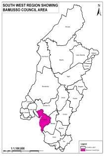
The headquarters of the Bamusso Subdivision is based in the maritime zone where the subdivision gets its name (Bamusso). Bamusso town is located some 40km from Mbonge. The Council has a total surface area of 885sq.km with an estimated population of 60,000 inhabitants living in some 36 villages and settlement areas (fishing ports). It is located between latitude 4033’N and longitude 9001’E with an altitude of about 80m in the mainland area above sea level and -5m in the maritime area which is below sea level.
The municipality has geographical boundaries with the Ekondo-Titi Council to the North, to the East by Mbonge Sub-division and Southeast by the West Coast Sub-division, to the West and Northwest by Kombo Itindi Council and to the South by the Atlantic Ocean. The average temperature range is about 300C and mean monthly rainfall of about 2500mm to 5000mm.
Contact Us
Information, Suggestions and Complaints
Email Us
Have you got a question orissue Drop a Line
Phone
You can call us on weekdays between 8am to 5pm.
Non Emergency
Call to find services, report or register complaint.
Social Media
Looking for the latest news, events & places to visit.